Thursday, June 19 Awoke at 0600,
after pancakes and coffee,
lifted the hook at 0705. toured the inner Rockport Harbor and headed out for Plymouth (or alternatively P-town). Temperature 62 F, light winds out of the south, partly cloudy--a beautiful day with unfavorable winds. Motoring.
I really wanted to go to Plymouth and anchor behind Clarks Island where the Mayflower spent the winter after arriving with the Pilgrims. Both Ryck and Tom were familiar with the channel and so this seemed like a perfect op
 portunity to work in there with some local knowledge on board.
0815 Londoner abeam to Starboard.
0934 42-32.8 N/70-34.3//4.1k@210M
1045 Boston Skyline visible ~22 miles distant.
Breeze died - turned from ~200M to ~225M expecting the breeze to fill in SW later. Trying to motorsail when the wind allows.
1110 Spoke to Rob Hurd G17 <=> G21 #83 is our mooring.Rob is the Waterfront Director at Tabor. He had arranged a mooring for us in Sippican Harbor off the Tabor dock for the weekend and this was just confirming where we were to go when we arrived.
1135 Warned off the LNG deepwater port by a work boat on station --put in GPS.
Stumbling onto the new LNG deepwater port was a navigational embarrassment. I knew perfectly well that this facility had been installed, but had looked at the rhumb line from Midcoast Maine and the Canal, had assumed that we would be well offshore and hadn't given it another thought. In fact, the facility lies right between Cape Ann and Plymouth and our course took us right through the area.
As we approached, we were on course to pass close ahead of a sizable workboat, I watched carefully for a bit and realized she was not underway so decided it was OK to cross her bow. I took the precaution of monitoring VHF ch 13 and 16; the boat came up on the radio and let us know what was going on. We were going between the two hookups to the pipeline, which were marked only by polypro pickup lines. We offered to tack away, but he said it was fine to go through so long as we stayed away from the actual pickups.
1202 42-20.7N/70-37.4W. Plymouth bears 190M distant 20.6 mi. Wind light & variable, generally Southerly & trying to establish a sea breeze. Sunny & comfortable in the cockpit.This was a pleasant afternoon, only marred by the necessity of keeping the diesel humming a lot of the time since we had quite a distance to cover to windward if we were to get to Plymouth at a reasonable hour.
Spent the afternoon beating to Plymouth.The finish was great.
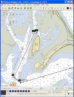
1800 Weathered the Gurnet & entered the channel with a bone in her teeth. Sailed up the channel & dropped sail just West of the S. end of Clarks I. then motored to the North end to anchor among the untenanted moorings. The key to the unmarked channel is to come in at about 035M and headed to the left end of the vegetation on the beach ahead.
 We swept into the entrance channel against the last of the ebb with a reef in the main, rounded the bug light and up the channel toward Clarks Island. The photo, by Ryck, shows Tom at the helm as we leave the Gurnet astern and slip by Browns Bank. Finally, we rounded up and dropped sail before the channel split and narrowed west of the island. When we got to the anchorage area, it was rather full of empty moorings and it was a bit of a trick to find a clear spot, especially since we didn't know the limits of the surrounding shoals. Happily it was low water, so if we were afloat, we were OK. So we poked around a bit and anchored near an Island Packet which had come in shortly before us.
1930 Anchor down & holding. Paul is again looking for the missing bottle of wine.
While Paul tried to solve one pressing mystery, we had our last dinner aboard and looked ahead to the morrow, when we would transit the Canal and, we hoped, arrive at Tabor for "cocktails under the great tent" and an arrival dinner with Betsy, Mary and Jenn, who would be meeting us. Ryck and I would be staying on to attend our reunion.


1 comment:
Duxbury Bay is a vast sheet of inviting, protected water ... at high tide. At low water, it's a maze of skinny channels surrounded by vast expanses of exposed sand bars. It's a great place for shallow water boats like Beetle Cats and the larger Marshall catboats, but there are few places for a deep draft keelboat. Fortunately, North Wind is closer to the former than the latter, and snuggled into the shallow slot near Clark's w/o difficulty. Sailing into Plymouth and Duxbury Bays takes time.
Post a Comment